(Please note that this is a large file with maps it might take some time to download)
Personal details of the presenter, retired Associate Professor Southern Cross University – lives in Pearl Beach, NSW
My name is Klaas Woldring, of Dutch origin. My wife and I arrived in Australia in May 1964. Not directly from the Netherlands; we migrated first to South Africa and lived there and in Northern Rhodesia for 4.5 years, Then re-migrated to Australia encouraged by Australians we met there. We became Australian citizens, that is single country citizens, in 1969. We lived 8 years in Sydney (5 and 3), 22 years in Lismore (NRCAE), then again 2 years in Zambia, teaching at the University there, then back to Lismore (SCU), retired in 1999. Arrived on the Central Coast (Pearl Beach) in 2000. This is my sixth year with U3A. I give courses on governance system problems and possible changes: Electoral system, Federation, the Constitution and What kind of Republic?.
So, I am not a professional specialist on old maps but my interest was greatly stimulated by the exhibition in Canberra end 2013 – beginning 2014 – which I attended twice with associates of the Dutch Heritage Centre (Smithfield) and the Australia on the Map Committee established in Canberra. This brings us to the first image.
Intro 1
Maps from National Library. Important history of continent. The Dutch made a great contribution in this respect. Library has made these maps available both on line and as hard copy replicas. They want to people to look at them use them for schools and exhibitions. Fairly in expensive in full size. We bought 25, already had some and presented to exhibitions for the 400 Dirk Hartog commemoration in 2016: Fairfield Gallery and Erina Foyer of the Gosford Library.
Intro 2
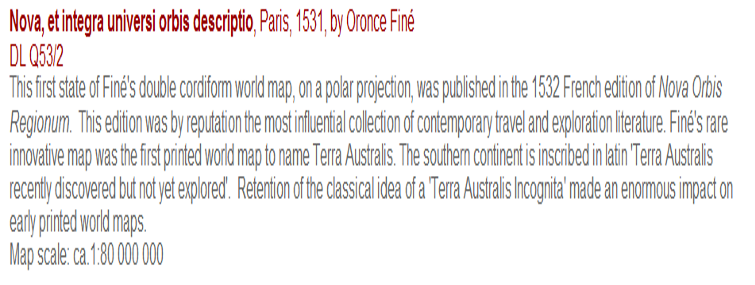
Map by Claudius Ptolemy (lived from AD 100 to AD 17), Roman mathematician, philosopher, cartographer, geographer, lived in Egypt, then a province of the Roman Empire – reproduced in 1454.
Intro 3
•World map, untitled, 1493 Hartmann SCHEDEL, 1440–1514
•One of the most fascinating printed books from the 15th century is the Nuremberg Chronicle. The work of Hartmann Schedel, it was first printed in Latin and German in 1493 and contained two maps: the world and Europe. This world map is from the Latin edition and was based on Ptolemy’s measurements, but without the same attention to geometric detail. Christopher Columbus’ 1492 discoveries were not included, nor was Bartholomeu Diaz’s discovery of the southern tip of Africa in 1487. The map combines Biblical beliefs with fiction, fantasy and legend.
Intro 4
Intro 5
1544 Gerardus Mercator was charged with heresy in 1544 on the basis of his sympathy for Protestant beliefs and suspicions about his frequent travels. He was in prison for seven months before the charges were dropped—possibly because of intervention from the university authorities. He moved to Duisburg where he taught mathematics at the academy. He constructed a new chart and first used it in 1569. It had parallel lines of longitude to aid navigation by sea, and compass courses could be marked as straight lines. Following his move to Duisburg, Mercator never left the city and died there, as a respected and wealthy citizen on December 2nd, 1594.
Intro 6
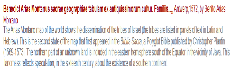
Commentary on Benedict Arias Montana’s map of 1572
Intro 7
Gerard Mercator’s great world map of 1569 was condensed into a double hemispherical form by his son Rumold in 1587. This new representation was incorporated into editions of Mercator’s Atlas and also printed separately, as shown by this example dating from around 1603. This map shows the late 16th century configuration of the world with a large Terra Australis in the south. In the years following this publication, this depiction of Terra Australis was copied and adapted by other mapmakers.
Intro 8
First an earlier map of Abraham Ortelius of 1570 – that is before 1600. Most of what follows is FROM 1600, with couple of exceptions. At the end we’ll look again at earlier maps, including a probable Portugese map of the East Coast of Australia drawn up by Nicholas Vallard (1547). Ortelius is recognised as a famous mapmaker of the period. He originated from Antwerp. In 1575 he was appointed geographer to the King of Spain, Philips II, who caused the Dutch a lot of trouble which actually resulted in the Dutch exploring then taking over the spice trace of the Portuguese in the East Indies.
Intro 9
The remarkable map of Cornelius de Jode (1593) suggests knowledge that there is sea between New Guinea and the mainland of Australia, even prior to the landing of Willem Janszoon. There appears to be no explanation for de Jode’s map.
Intro 10
First visit by Dutch in 1606: Willem Janszoon in the Duyfken. To what later was shown to be the West Coast of Cape York but believed to be, by Janszoon and his crew an extension of New Guinea, which was known and had been mapped.
The Duyfken was a very small ship, one of a group of eleven Dutch ships that arrived in 1598 in the Indies and made a successful start with the subsequent spice trade by the VOC (Vereenigde Oost-Indies Company), which was formally established in 1602 as the first company finance by shares, and the first company that was actually multi-national. Janszoon probably never realised that they had landed on the Great Southland Australia. In that same year The Spaniard Luiz Vase de Torres, sailing with an expedition from Peru, sailed through the passage. Apparently, he also did not realise that he had sailed between New Guinea and the Great South Land Australia. Nor did these two explorers know of each other’s journeys.
This was the start of several other landings by VOC ships, some accidental but most to discover the extent of the Great South Land. A map of these voyages was engraved in the new Amsterdam Town Hall, completed in 1648, later made into a Palace for the Orange Monarchy – now called Palace of the DAM. A similar engraved map is on the floor of the lobby of the Mitchell Library in what was then “the new wing” of the Mitchell Library, Sydney, in 1942. Very well done. I presume that the people responsible for that had seen the map in Amsterdam prior to WWII (Tom Mutch).
Replica Duyfken. Built in Fremantle prior to 2006 commemoration of 400 years trip to Cape York and mapping of 300 kms of the coast line. -This reconstruction there followed on the building of replica of the Endeavour, Captain’s Cook ship The replica Duyfken made a tour in 2006 of the East Coast and public meetings were held in major harbours. I addressed such a meeting in Newcastle when in harbour there on behalf of the Australia on the Map Committee (Canberra). Also reminded the about 200 people gathered there that their steel industry was started by Guillaume Delprat, a Dutch metallurgist who was General Manager of BHP Ltd in Broken Hill from 1899 to 1921. Most people there were very surprised to hear that. There were other interesting Dutch pioneers in 19th century as for example the Paling family who were initially attracted to the gold mining activities (1850s) but were actually publishers of sheet music and later also sold musical instruments. Duyfken now permanently parked in Sydney Harbour near Maritime Museum.
Intro 11
This seafarer, Jan Carstenszoon had real problems with the Indigenous people, unlike Willem Janszoon. A fight broke out when they tried to capture an Indigenous human being to examine what they were like – basically for scientific study. Not surprisingly this was the wrong idea, people were killed on both sides. The Dutch did not succeed and fled the area.
Intro 12
In 1616 Captain Dirk Hartog (1580 – 1621), master of the Dutch East India Company ship Eendracht (meaning “unity”), stepped ashore on an island off the coast of northern Western Australia,.This island is now known as Dirk Hartog Island. This was the second recorded European expedition to land on the Australian continent but the first to do so on the western coastline. Hartog named the area Eendracht’s Land but the name has not endured, the area now being known as Cape Inscription. Hartog was a ship owner and the captain of his ship who came from Amsterdam. He was only three days on the island and left a pewter plate, the first time anything written was left on the continent.
Before he left, Hartog had a pewter plate nailed to a post, with an inscription:
Intro 13
The Hartog pewter plate was on loan first in the Western Australia Museum, Perth, then in the Maritime Museum, Darling Harbour for several months. Saw it there and also listened to a talk by a Dutch professional conservator which made it clear that maintaining such items is a big job which requires more than Super Glue. It is usually kept in the Rijks Museum in Amsterdam. The Dutch Heritage Centre managed to obtain 6 replicas of it – as a donation from the Australia on the Map Committee, in 2007. Funny the current President of the DACC was in Amsterdam, in 2016, visited the completed reformed and renewed Rijks Museum in 2016. Asked where is the Hartog plate, went to the third floor, where it usually is kept, and then found that it was in on loan Australia!
Intro 14 – no comment
Intro 15 – 1628 Showing coastline visited by Peter Nuyts (until Ceduna) 1627, earlier Cape Leeuwin (1622), Land of Edels, Houtman.
Intro 16
Commentary on the Batavia ship wreck and mutiny in 1629 – Abrolhos Islands (chain of 122 islands WA)
Ongeluckige Voyagie, van’t Schip Batavia. Disastrous voyage of the ship Batavia]. Amsterdam, 1647.
The mutineers attacking the other survivors of the wreck of the Batavia
The woodcut illustrations in this book are the earliest printed views of any part of Australia. The book also includes descriptions of the Australian coast and the first published description of a kangaroo: ‘a species of cat, which are very strange creatures – the forepaws are very short – and its hind legs are upwards of half an ell [c.36 centimetres], and it walks on these alone’.
Intro 17 Painting (1637) tell the story of Bosma visiting DACC.
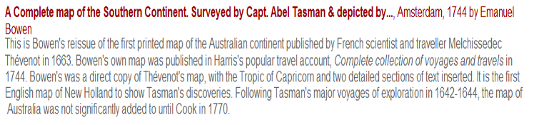
Intro 18 Commentary on the incomplete map.
*Interestingly, the whole of the southern, eastern, and lower western portions of the Australian continent are completely missing. Also at the time, Bass and York Straits were not then presumably known. There are some tantalising questions here, like the relative completeness of the Gulf of Carpentaria and the realistic outline of southern Western Australia (not visited by Able Tasman!) Was this a good educated guess or of some deeper knowledge that we do not know about?
Intro 19
*Tasman’s first voyage 1942, starting in Mauritius going down to 40 degrees south eastward. Map from Tasman’s own records. They took on food and water in Mauritius, then went well south to pick up stronger winds and hit on Tasmania’s west coast. Crew went ashore and were inspected by Indigenous women as to their sex (men or women). Mapped what they saw, went on to see if they could go as far as South America. Straight Magellan which was well known.
Tasman had instructions to see if they could reach South America that way. Also test for gold and spices. Second blockage was New Zealand, not known at all. Landed on the South Island, then on the North Island. Never knew if these were islands or part of the Great South
Land. Quite serious conflict with Maoris. Named Tasman Van Diemens Land (then G-G of the Indies). They were moderately pleased with Tasman there. Well respected as a navigator though, undertook various high level tasks on a sort of part time basis but also remained in Batavia as a merchant.
Intro 20
This is the Bonaparte Map on the floor of the Mitchell Library (1942) and the new Town Hall of Amsterdam (1648), later serving as the Palace of the Dam for the House of Orange (since 1815).
The name Bonaparte comes from the original owner, a French nobleman, a relative of Emperor Napoleon Bonaparte.
Intro 21 Map by Jan Jansson of the Dutch Indies of 1630
Intro 22 Tasman Map of 1644 – after his second journey, starting in the Gulf of Carpentaria
Intro 23
Hondius map – Corners are filled with native scenes, including animals, birds, boats and a representation of a penguin and of a penguin being hunted. Title in cartouche and a blank cartouche which was probably intended for a dedication.
Hemispherical map, with notes, centred on the South Pole to the Tropic of Capricorn., includes southern parts of South America and South Africa and the west and south coasts of Terra Australis Incognita.
Also available in an electronic version via the Internet at:
http://nla.gov.au/nla.map-t727.
Exhibited: “Mapping our World : Terra incognita to Australia”, National
Library of Australia, Canberra, 7 November 2013 to 10 March 2014. ANL
Intro 24 Map by Jan Jansson 1650
Physical Description: 1 map : col. ; 41.8 x 53.3 cm.
Notes: Map of the Indian Ocean and surrounding countries.
Australia called Terra Del Zur. Relief shown pictorially.
From: Atlantis majoris… Amstelodami : Apud Ioannem Ianssonium, 1650.
Exhibited in online exhibition: 34zBSouth Land to New Holland”34y Bat http://www.nla.gov.au/exhibitions/southland/ANL
Subjects: India — Maps — Early works to 1800.
Indian Ocean — Maps — Early works to 1800.
Intro 25 Creator: Allardt, Hugo, approximately 1628-1691.
Date of Map est. 1665
Notes: Map of the Indian Ocean and surrounding countries including Australia, Indonesia and China. Relief shown pictorially.
From an untitled collection of 29 maps, the majority contemporarity coloured. Amsterdam, (c. 1665).
Title cartouche, and scene of elephants and camels working.
European sailing ships only.
Shirley, R. Maps in the atlases of the British Library, T.ALL-1a
Subjects: Indian Ocean — Maps — Early works to 1800.
Call Number: MAP T 40
Amicus Number: 23488138
To cite this item use: http://nla.gov.au/nla.map-t40
Intro 26
Originally issued by Pieter Goos, this map broadly defines the west coast of Australia. After Goos’ death in 1675, the van Keulen family acquired the plate for this map and reissued it, generally trimmed to accommodate the atlas format. This chart is one of only five known in an untrimmed state. It is considered to be one of the rarest and most beautiful large-scale 17th century Dutch charts of the East Indies and was produced with the intention of appealing to a wealthy patronage.
Publisher: Amsterdam : Johannes van Keulen , [1690?].
Physical Description: 1 map : col. ; 61.3 x 88.5 cm.
A most embellished map of the East Indies. First fashioned by
Goos after Doncker’s t’Ooster deel van Oost Indien (1660),
This edition was published by van Keulen after 1680 and before his retirement in 1704. Tony Campbell (Early maps, 1981) considers Goos’ original as probably datable to 1658, “the first newly engraved map to name all the Dutch discoveries in Australia”.
Relief shown by bathymetric soundings.
Plate found in the sea-atlases and Zee-fakkel of the Van Keulens.
Also available in an electronic version via the Internet at:
http://nla.gov.au/nla.map-t792
Intro 27 and 28
Map of 1753, First chart of Willem de Vlamingh but actually the journey took place in 1697 and 1698. We also have ONE replica of the de Vlamingh plate in Smithfield. He took the Hartog plate back to Amsterdam.
This is the first printed chart of Willem de Vlamingh’s voyage along the Western Australian coast in 1697. It was published in Johannes van Keulen, Nieuwe groote lichtende zee-fakkel… [New great shining sea torch…], vol 6, Amsterdam, 1753.
The West Coast of Australia is shown here as running from East to West instead of South to North, not uncommon in the 17th century. Shark Bay is in the Centre and West of that is Hartog Island. It is amazing that it took more than half a century before the charting expedition of 1697/8 was actually printed. De Vlamingh found the pewter plate left behind by Hartog and erected his own pole with an engraved plate from himself, starting with the text found on the Hartog plate and adding his own commentary. DACC has replicas of the Hartog Pewter Plate and the De Vlamingh Plate•In 1801 Captain Hamelin on the Naturalist, a ship from a French expedition led by Nicholas Baudin, entered Shark Bay and a party was sent ashore. By chance the party found the Vlamingh memorial of Dirk Hartog’s previous visit, though the plate was almost buried in the sand. When the party returned the plate to the ship, Hamelin ordered it to be returned, considering it somewhat sacrilegious to have removed it. One of Hamelin’s officers, Louis de Freycinet, felt that this action was inappropriate and that such a trophy should be taken and returned to Europe.
In 1818 Freycinet returned to Shark Bay, now in command of his own vessel, and was able to find the plate still in place at Cape Inscription. He removed the plate and returned it to Europe where it was presented to the French Academy in Paris.
+
The Vlamingh’s plate then disappeared for more than a century until it was rediscovered in 1940 on the bottom shelf of a small room of the French Academy mixed up with old copper engraving plates. In May 1947 the French Ambassador to Australia presented the plate to the Right Hon. J.B. Chifley, who received it on behalf of the Commonwealth. In 1950 it was returned to Western Australia, where it can be seen in the Shipwrecks Galleries of the Maritime Museum in Fremantle. SEE: http://museum.wa.gov.au/research/research-areas/maritime-archaeology/batavia-cape-inscription/cape-inscription/hartog
Commentary of the de Vlamingh’s second chart
According to Günter Schilder’s Voyage to the Great South Land, Willem de Vlamingh with a fleet of three ships, Geelvinck, Nijptangh and Weeseltje, undertook in 1696-97 the last large-scale voyage undertaken by the Dutch East India Company. One of its objectives was to investigate the disappearance of the Company’s ships believed to have been wrecked on the coast of the Great South Land. In succeeding in this task Vlamingh was the first to arrive intentionally at the coast of Western Australia, then named Land of the Eendracht (a reference to Dirck Hartog’s exploration aboard the Eendracht making the first recorded accidental discovery of this land in 1616). Vlamingh’s crew first sited Rottnest Island on December 29, 1696. On January 4 1697 they began surveying the mainland coastline from Swan River up to Exmouth Gulf before departing for Batavia on February 21. Vlamingh in fact made a detailed chart of the Western Australian coastline in his ship’s journal but that was subsequently lost in Batavia.
Intro 29
Intro 30 Commentary on Joan Blaeu’s map
This map first appeared in the 1662 Latin edition Atlas Maior. Its importance is in the plotting and labelling of Tasman’s first journey, Blaeu was the first to attach the name Hollandia Nova [New Holland] to the Australian continent in 1645, which did not fade from use until the 1820s; voyage’s [1642–43] discoveries in Tasmania and New Zealand. Tasmania is named Antony van Diemens Lant. Several other early Dutch discoveries in Australia are also shown, including Hartog’s [1616], Houtman’s [1619], Cartensz’s [1623], de Witt’s [1628] and Nuyt’s
Intro 31
This map of Nicolaas Visscher portrays the world as it was known in the late 17thcentury and is presented in the form of large eastern and western hemispheres, with smaller northern and southern polar projections. It is one of the earliest world maps to show Tasman’s 1642–43 and 1644 discoveries in Australia.
Intro 32
This map is one of de Leth’s foremost works and an example of the best in 18th century Dutch cartography. Encompassing much of the world, including all of the Atlantic and Pacific Oceans, it includes a wealth of geographical, historical, practical and anecdotal information, including commercial sea routes and the paths of famous explorers like Magellan, as well as inset plans of important port cities. Geographically, the map has interesting anomalies that illustrate indecision at the time, especially with respect to Australia and its uncharted coastline
Intro 33
A map by an Italian cartographer Antonio Zatta, also shows a lot of new discoveries in the Pacific. First evidence of Italian interests.
This is the first edition of the first decorative map to show Cook’s tracks in the Pacific. It is a typical example of the effect Cook’s discoveries had on European cartography. Australia regularly became a focus on regional maps. The vessel illustrated in the map’s vignette is possibly the ?? Endeavour
Intro 34
1777 A French chart of Australia and New Zealand showing the discoveries made by Cook in 1770, during his first voyage and the discoveries made by Capt. Furneaux in Tasmania in 1773. Australia is labelled ‘Nouvelle Hollande’ and charted to include Cook’s 1st voyage discoveries on the east coast, including place names given in French such as ‘Baye de Botanique’ and ‘C. de la Fume’ (Smoky Cape near South West Rocks). ‘Nouvelle Galles Meridionale’ (New South Wales) occupies the entire length of the eastern coastline and Tasmania is tentatively attached to the mainland.
A few of the Dutch discoveries in Australia are mentioned such as Pieter Nuyts’ in 1627, van Colster’s 1623 discoveries in the ‘Arnhem’ and Leeuwin’s 1622 discoveries on the southwest coast (labelled ‘Terre du Lion’ on this map). Endeavour Straits are labelled ‘Detroit de l’Endeavour’ and in New Zealand, Cook’s Straits are named ‘Detroit de Cook’. The Tasman Sea is labelled ‘Mer Pacifique’
Intro 35
A 1790 map by Kinkaid, clearly post -Cook’s arrival and the mapping of the East Coast. Morer details of Sydney harbour here.
Intro 36 Another Italian map Cassini
1798 Following the much publicised, landmark discovery of Australia’s east coast by Captain James Cook in 1770, mapmakers around the world were quick to incorporate those discoveries onto their maps. Ironically, only a small handful of rare maps from that lot, concentrate on the whole Australian continent itself. Cassini’s highly decorative map of Australia, is only the third such map (following the very rare 1779 pocket atlas map by de Baillou – see cat.77, and Eden’s rare 1787 map – M357). It charts the discoveries made by Cook on the east coast of Australia, and labels many of them in Italian. The map features at the top left, a decorative vignette with natives and a ship. Australia is named Nuova Olanda and New Guinea is named ‘Nuova Guinea, O Terra de Pappagalli’ – land of parrots. The Indian Ocean (‘Mare delle Indie’) is shown to be on both sides of Australia.
Intro 37 first full map of Australia by Louis Claude Freycinet. 1811
Intro 38 second map by Pierre Lapie
1814 Only the second published, complete map of Australia and the first to name Flinders’ discoveries. Lapie’s fine map of Australia was published just one year after his fellow compatriot, Louis Claude Freycinet’s map, which lays claim to being the first complete map of the continent. Lapie’s map closely follows the geography of Freycinet’s, which at the time was the only one to detail the charting of the south-west coast of Australia, recording the exploits of the 1800-1804 Baudin expedition. The French INITIALLY chose to completely ignore the British discoveries by Flinders, in spite of the fact that he had charted most of the coast before the French. As a result, only French names were used for this part of the coast on Freycinet’s map such as ‘Terre Napoleon’, ‘Golfe Josephine’ and ‘Golfe Bonaparte’. This was a clear attempt by the French to claim for themselves, the south-east coast of Australia
Intro 39 (continued)
The English territorial claims by Cook on Australia’s east coast were respected however. At this stage, Flinders’ account of his own circumnavigation of Australia with its compliment of maps had not been published. That occurred in 1814, following his release from six and a half years in captivity on Mauritius by the French. Once the English had been supplied with proof that Flinders had charted the south-east before the French, a fair degree of political friction occurred between the two countries. Lapie’s map is of great interest because unlike its predecessor (Freycinet’s map), Lapie makes three acknowledgements of Flinders (and Grant’s) presence in the area: T.decres’ (‘I. des Kangourous selon Flinders’); ‘C.Bouflers’ (‘C.Northumberland selon Flinders et Grant’); ‘C.Brune’ (C.Catastrophe selon Flinders’). It is therefore the first published map of Australia to acknowledge Flinders’ discoveries. Lapie’s map features an attractive vignette of a wombat, bandicoot, Aboriginal and a canoe – based on illustrations by Lesueur. Charles Lesueur was the young artist on Baudin’s voyage, famous for his fine illustrations of Australian animals. Pierre Lapie was the first geographer to the King of France and chief of the topographic section of the War Office.
Intro 40
1814 Matthew Flinders printed his account of his discovery and charting of the Southern coastlines of Australia shortly before he died. This map printed the same year as Flinders’ is an excellent representation of one of the first ’complete’ maps of the continent. Flinders actual map can sell for over $20,000, so this piece offers tremendous value. If you look closely at the area around Spencers gulf you can see that the ink is a bit darker, showing that it has been newly added to the map. Australia at this time was still commonly known as New Holland.
Intro 41
Intro 42 I hope we have time for this.
Part of the Flinders Story
Leaving Port Lincoln on 6 March (1802) , they proceeded north to see if the body of water might lead to the Gulf of Carpentaria. Hopes were dashed when the impressive gulf ended in a salty swamp. Kangaroo Island, named by Flinders, was sighted on 20 March and 31 kangaroos were shot, providing much needed fresh meat for steaks and soup. Their skins were made into caps for the sailors. The next significant landmark sighted was the St Vincent Gulf.
On 8 April, a ship was sighted coming from the east: Le Geographe, commanded by Nicholas Baudin. When Baudin left Le Havre, France, in October 1800, he was in charge of one of the best equipped voyages of discovery ever mounted. His aim was similar to Flinders’ – to complete the charting of Australia, as well as investigate people, plants, animals and minerals of the largely unexplored land. Flinders and Baudin met on successive days on Le Geographe outside Encounter Bay, South Australia (named by Flinders to mark the event).
The East Coast: May 1802- March 1803
Matthew Flinders spent ten weeks in Sydney from May 1802. The Investigator was moored near the present-day Sydney Opera House, with a camp established on shore nearby. The ship was repaired and painted. Flinders worked on his charts and the scientists went exploring. Flinders was pleased with his achievements and wrote to his wife that he was now a person of some consequence.
In late June, Nicolas Baudin on Le Geographe entered the port. He was shown hospitality by the Governor, Philip Gidley King. Many of his men were ill and they were given medical attention. Flinders would later contrast this reception with how he was received at Mauritius, then a French colony.
Flinders incarcerated at Mauritius by French Governor on the way back to England – for more than six years.
A trio of vessels – Rolla, Francis and Cumberland – left Sydney on 20 September 1803 bound for Wreck Reef, arriving on 7 October. Some of those stranded on the sandbank would join Rolla which was bound for China; others would go back to Sydney on Francis. A group of ten volunteers would join Flinders on Cumberland (about 11 metres in length), to complete the survey of the Torres Strait on the way back to England. Yet the Cumberland was not up to the task ahead. Flinders had recorded on 24 September 1803, having only just left Sydney, that she was ‘exceedingly crank’ and ‘very leaky’. By early December 1803, the condition of Cumberland was such that a decision was made to call at the island of Mauritius, then a French possession, 1800 kilometres east of Madagascar in the Indian Ocean. Flinders hoped to obtain a replacement ship there. Accused of being a spy, he spent over six years in detention on the island.
The man who imprisoned Flinders was the Governor of Mauritius, Charles Mathieu Isidore Decaen. He was a patriot, a strong supporter of Napoleon, and saw his role as helping expel the British from India. In August 1805, Flinders received permission to live in the island’s interior. He resided on the plantation of Louise d’Arifat, a widow, though he was not allowed to go more than ten kilometres from there without Decaen’s permission. Flinders delighted in exploring the scenic beauty of the area, examining it with a scientist’s eye. He learnt French, read, visited neighbours, played tric-trac (backgammon), attended parties, and dances. He also learnt to play chess. In many ways it was not an unpleasant life. His friends and activities helped ease his mind. But still he heard nothing of his release and his absence from Ann was taking its toll. In late 1806, he suffered a period of acute depression. Attempts to have Flinders released were made but Decaen did not agree to free Flinders until March 1810.
He arrived back in Porthmouth and found his wife Ann still alive and waiting for him, after nine years. The couple had a daughter in 1812. His book A Voyage to Terra Australis, with accompanying atlas – the summary of his life’s work – was published on 18 July 1814. Flinders died the next day (although he had seen a copy earlier).
End
The final maps are comparison done by the Australian Peter Tricket who wrote a somewhat controversial book about the Portuguese discoveries by Capt Mendonca on a journey in 1521 and 1522 along the Australian East Coast. In his book Beyond Capricornia (2007) he reorganised the portolans left by Mendonca to show that they actually mapped the East Coast quite properly and compared the result with the actual East Coast – a remarkable likeness. Australian historians are some sceptical of this work because the Portuguese left nothing behind on the coast although
there is mention of an old ship that was stranded on the south coast (near Warnambool?) and discovered in the 19th century apparently (but gradually disappeared). This could have been a Portuguese ship so it is claimed. I find the claim by Tricket credible. The Nicholas Vallard Map of 1547 is the one that was made on the basis of this philosophy.